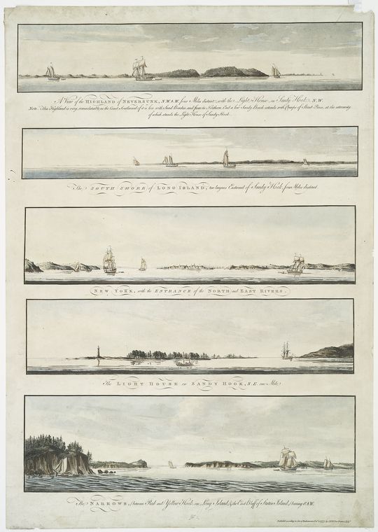
Five Views of the Entrance to New York Harbour, 1777
1777
Approaches to New York Harbor from Sandy Hook to the Narrows (general area)
Five coastal profiles on one sheet, engraved for the Royal Navy's use in the American war and published in Joseph F. W. Des Barres's Atlantic Neptune. Top to bottom: the Highland of Neversunk from four miles out to the north-west by west, with the Sandy Hook Lighthouse to the north-west; the south shore of Long Island from four miles out; New York from the harbour with the entrance of the North and East Rivers; the Sandy Hook Lighthouse from one mile to the north-east; and the Narrows between Long Island's Red and Yellow Hooks and Staten Island's east bluff, bearing south-west. These are the panels a pilot memorized. This is the shape of the hook, thirteen years after the light was first lit.
Item record
- Title
- Five Views of the Entrance to New York Harbour, 1777
- Date
- 1777
- Source
- Joseph F. W. Des Barres · from the Atlantic Neptune · London · 4 October 1777 · scan from the New York Public Library
- Contributor
- The New York Public Library · Lionel Pincus and Princess Firyal Map Division · The Miriam and Ira D. Wallach Division of Art, Prints and Photographs
- Rights
- Public domain (published 1777)
- Slug
des-barres-five-views-1777
Verification: unverified.
Cite this item
Five Views of the Entrance to New York Harbour, 1777 (1777). Joseph F. W. Des Barres · from the Atlantic Neptune · London · 4 October 1777 · scan from the New York Public Library The Highlands History Project, https://history.abovethehook.com/archive/des-barres-five-views-1777/.