Chapter 1

The Navesink

Before record · The Navesink band of the Lenape

The land had names before it had a deed.

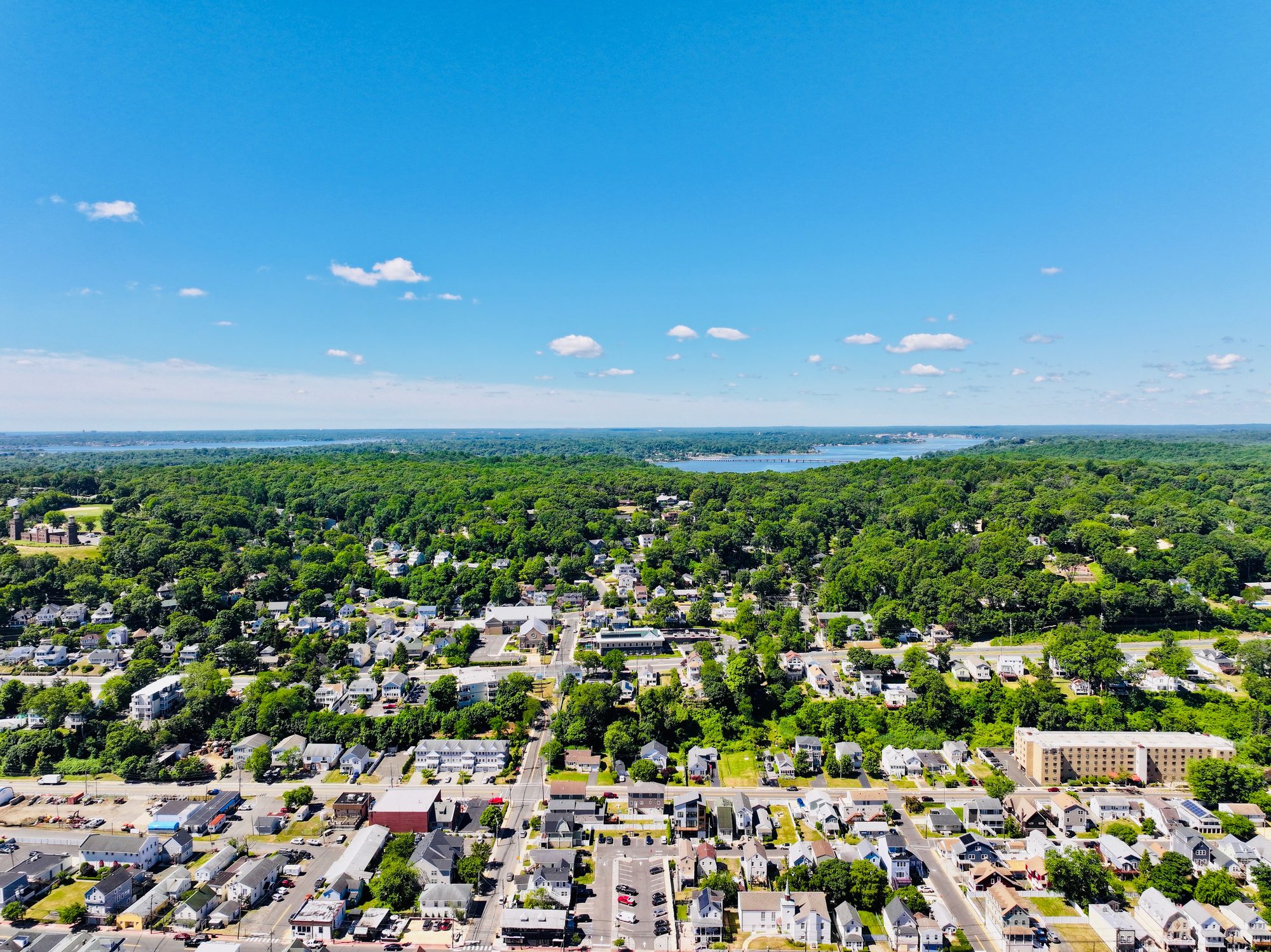
A high aerial photograph on a clear summer day. In the foreground the streets and rooftops of Highlands; beyond them a wooded ridge under dense green canopy, with the brownstone Twin Lights station and its two towers on an open lawn at the left. Past the ridge a broad river runs across the frame with a long low bridge on piers, houses and a marina along the far bank, and wooded country to the horizon under a blue sky.

Aerial photograph by Above the Hook · 16 June 2026.

Thirty feet wide. Fifteen feet high. Made entirely of oyster shells. A midden on the Bayshore near the old Oyster Point Hotel — and not the only one. Similar mounds turn up in a rough rhythm along this shoreline, about every eight miles, as if the people who built them were a day's walk apart.[1]

A shell midden is refuse, not a monument. But refuse this size only piles up one way — a family working the same oyster bed for generations, not passing through.

This is the plainest evidence for the oldest part of the story. People were living on this coast, working this bay, long before the first sail off it was ever recorded.

The Navesink were a Munsee-speaking Lenape people, and they held the peninsula and the highlands south of it.[2][3] The Highlands are named for them. So is the river.

Nearly everything came from that water and that ridge. Oysters and clams from the bay. Fish and fowl from the flats. Deer and small game from the highland woods. From the shore itself, seals and porpoises, sometimes a stranded whale. Round-roofed wigwams, not the Plains tepee, went up and came down with the family as the seasons moved them between shore camp and the woods behind.[4]

None of this was passage. It was a life keyed to a place, repeated long enough to leave shell middens the height of a house.

Say the names out loud and the Navesink are still here, whether the map admits it or not. Navesink. Rumson. Manasquan. Mantoloking. Manalapan. Wanamassa. Wickatunk.[1] Every one of them Lenape before it was anything else — a sound the English kept because they had no better word for the place, and never quite managed to make their own.

History didn't begin here with Columbus in 1492.

Claire Garland, who directs the Sand Hill Indian Historical Society, offers an origin further back than any deed. By her account, European fishing crews were trading along this coast as early as the twelve hundreds — three centuries before Verrazzano ever wrote a letter about it.[1] No independent written record confirms that date. It is reported here as she gave it, not as settled fact.

Four sounds the English kept

Walk the shore in four names. Popamora Point, at the base of the peninsula. Navesink, the hamlet on the ridge. Rumson, across the river. Manasquan, twenty miles south. The map cannot plot how old these names are. It can only show how far they run.

Four Lenape place-names along the Navesink shore A schematic cream-and-navy coastal map. A low navy ridge sits on the left; a curving peninsula outline reaches from mid-frame up to the top-right and hooks. A dashed rust shoreline runs the bay bottom. Four rust dots mark Popamora Point (at the base of the peninsula), the hamlet of Navesink (inland on the ridge), Rumson (across the river), and Manasquan (twenty miles south down the shore). Four overlaid states highlight one place at a time as the reader scrolls; only the current state is fully visible. FOUR SOUNDS THE ENGLISH KEPT N Schematic · drawn by Above the Hook · not to scale POPAMORA POINT for the sachem whose name is on a deed NAVESINK the people’s own name RUMSON from Naromsonak MANASQUAN twenty miles south, still Lenape
Schematic · drawn by Above the Hook · not to scale.

Popamora Point

At the base of the peninsula, on the Highlands ridge. Named for the sachem whose name is on the 1664 deed. The deed ran out. The name is still there.

Navesink

A hamlet on the ridge above the river of the same name. The Navesink's own name for themselves, kept on the sign after the English took the ground.

Rumson

South across the Navesink River. From Naromsonak — the English shortened the Lenape word and the shortened form is what people say today.

Manasquan

Twenty miles south down the shore, at the mouth of another river. This one the English kept whole. Four sounds the English kept, four names still saying who was here first.

The paper trail for what happened next is not one story. It is several, and they do not agree.

Land Itself already gave the bones: a 1664 deed, Navesink sachems among the signers, Popamora's name in the colonial record. Look closer and it gets less settled, not more.

One Monmouth County account dates the sale to March 25, 1664. It names Popamora — "chief of the Munsey-speaking Lenape of the Navesink region" — as the seller. The tract runs from Sandy Hook and Rocky Point west to Keansburg, east to the Navesink Highlands, Raritan Bay to the Navesink River.[3]

A separate account gives the same year — 1664, the year the English took the Dutch colony — but names the sitting Navesink sachem as Passachquon, not Popamora.[2] And a further, earlier tract-sale sits on the record too: Cornelius Van Werckhoven buying ground called "Nevesings" in November 1651.[2]

This project does not pick a version and call it the settled one. It reports what the records say. And that they disagree.

What the record does agree on is the shape of what followed. On April 8, 1665, deputy governor Richard Nicolls granted twelve patentees — mostly Quakers, mostly from Long Island — a triangular tract from Sandy Hook to the mouth of the Raritan and southeast to Barnegat Bay. The Monmouth Patent. The paper origin of the county this project is written in.[5]

The Patent's own terms required that dealings with, in its words, "the land's indigenous inhabitants" carry "the appearance of propriety."[5] What that phrase concedes, carefully, is that appearance was the standard being met. Not consent. Not shared understanding. Not a fair trade.

By the account preserved at Monmouth Timeline, the Navesink kept camping, hunting, and fishing this ground for another twenty years after the first deed, before agreeing to sell those rights away too.[3] That is not the timeline of a people who believed they had sold their homeland outright in one afternoon in 1664.
Sandy Hook is a unit of Gateway National Recreation Area now, run by the National Park Service. The Park Service's own page on the peninsula's people asks who Fort Hancock's Hancock was, who Gunnison was, who kept the lighthouse running, whether Tom Mix really filmed here.[6] It is a good list. It does not include the Navesink. Not once.

That is not a conspiracy. It is what happens when a park's history starts at the fort gate. But Land Itself already named this pattern once, in a letter written two hundred and sixty years before the fort — the chart is silent about the people already living on the land it charts. The chart has changed since. The silence has not.

Bridgeton. Mahwah. Lincroft.

None of those three communities can trace an unbroken, documented line back to the specific sachems who signed those seventeenth-century deeds. Say that plainly, because overclaiming a lineage would be its own kind of erasure. What can be said is that Lenape people did not vanish from New Jersey, whatever a chain of deeds implies.

The Nanticoke Lenni-Lenape Nation of New Jersey, headquartered in Bridgeton, describes its own history in its own words: descendants of "those Nanticoke and Lenape who remained, or returned," to this homeland after removals sent much of the wider Lenape world to the Midwest and into Canada.[7]

The Ramapough Lenape Nation holds the Ramapo Mountains northwest of here, out of Mahwah in Bergen County.[8]

And closest to this stretch of bay, the Sand Hill Indian Historical Society traces Lenape and Cherokee families — the Reveys and the Richardsons — from Eatontown to a fifteen-acre hillside in Asbury Park in 1877, the hill that gave the community its name. Monmouth County proclaimed a Sand Hill Indian Day in 2004.[9]

This chapter is built from what those communities publish and what the colonial and county record preserves — not from a seat at their table. That is the honest limit of it, and it is said here plainly rather than dressed up as more. A fuller telling is theirs to give, if and when they choose to give it.

Sources

  1. August 31, 2018, “The Lasting Lenape Legacy on the Navesink”. Scan Source for the shell-midden description (30 ft. by 15 ft., near the Oyster Point Hotel, recurring roughly every eight miles along the shoreline), the list of Lenape-derived place names (Wanamassa, Mantoloking, Manalapan, Manasquan, Wickatunk, Navesink, Rumson), and Sand Hill Indian Historical Society director Claire Garland's on-record quotes.
  2. Navesink tribe. Wikipedia. Link unverified Tertiary source, cited specifically to document a naming conflict: this article names Passachquon as the Navesink sachem at the 1664 transition from Dutch to English rule — a different name than Popamora, who a separate Monmouth County account names as the seller of the same-year tract. Also the source for Cornelius Van Werckhoven's November 1651 purchase of a tract called "Nevesings," and for Richard Hartshorne's 1668 purchase of "the whole peninsula ... called Portland Poynt." Not independently verified against the primary sources this article itself cites (Ruttenber's History of the Indian Tribes of Hudson's River).
  3. Lenape Chief Sells Navesink Highlands. Monmouth Timeline. Link Dates Popamora's sale to March 25, 1664, and records that the Navesink continued to camp, hunt, and fish the tract for roughly twenty more years before selling those usage rights as well. Cites Ellis (1885) and Salter (1890, 1997, 2001) without attributing specific lines to either.
  4. Herbert C. Kraft. The Lenape — Archaeology, History, and Ethnography. New Jersey Historical Society. 1986. Standard New Jersey-wide reference for coastal Lenape subsistence practices and material culture (wigwam construction, seasonal camp movement) cited generally, not as a Navesink-band-specific archaeological finding.
  5. The Monmouth Patent. Monmouth Timeline. Link Source for the April 8, 1665 Monmouth Patent, its twelve patentees, its geographic extent (Sandy Hook to the Raritan to Barnegat Bay), and the "appearance of propriety" language describing the standard Native land dealings were required to meet. Cites Hodges (1997), Salter, Ellis, and the Delaware Tribe of Indians' own materials.
  6. Sandy Hook: Who's Who?. National Park Service, Gateway National Recreation Area. Link NPS's own interpretive page on the people of Sandy Hook — covers Winfield Scott Hancock, John Gunnison, Tom Mix, lighthouse keepers, and U.S. Life-Saving Service members. Contains no Lenape or Navesink content, confirmed by direct reading in July 2026.
  7. Nanticoke Lenni-Lenape Tribal Nation. Nanticoke Lenni-Lenape Tribal Nation. Link The nation's own history page. Headquartered in Bridgeton, Cumberland County — south Jersey, not the Navesink region.
  8. Ramapough Lenape Nation. unverified Based in Mahwah, Bergen County — not the Navesink region. No stable official URL could be confirmed as of July 2026 (see the same note on this source in land-itself.yml).
  9. Sand Hill Indians. Native American Genealogy, Lincroft. Link The only one of the three communities actually rooted in the Navesink/Monmouth County region. Source for the Revey and Richardson family history and the 2004 Monmouth County proclamation.