Henry Hudson was not first. He was, at best, third, and the 85 years before him are the part of this story that usually gets cut.
On April 17, 1524, a Florentine sailing for the French crown brought a ship called La Dauphine into the lower bay. Giovanni da Verrazzano had been sent by François I to find the same passage everyone was looking for. He worked up the coast from the Carolinas, came in through the outer harbor, and anchored at the Narrows — viewing the lower and upper bays and, probably, the mouth of the river, without going up it.[5] He was met by canoes. Thirty of them, by his account, full of people who came out to look at him.
He named the place Angoulême, after his king's former title, and the bay Santa Margarita, after the king's sister. Then the weather turned against him and he stood back out to sea, north toward Narragansett Bay, where he stayed a fortnight and wrote at length about the Narragansett people.
He was back in Dieppe by July 8 and wrote his report to the king the same day.[6]
His letter to François I is the first European description of this harbor and of the people north of Florida.[6] It is also, in its own quiet way, a document about theft. Earlier on that same voyage, somewhere on the Delmarva coast, Verrazzano's crew took a child — carried a boy away from an older woman to bring back to France, and by Verrazzano's own account tried to take a young woman too and were stopped only by the noise she made. He wrote it down in a letter to a king, as an incident worth reporting, in a voyage otherwise full of praise for the beauty of the land and the generosity of the people in it.
The following autumn another ship came. La Anunciada, fifty tons, built for the purpose, out of Corunna on the twenty-fourth of September, 1524, with twenty-nine men aboard.[7]
Estêvão Gomes was a Portuguese pilot in Spanish service who had deserted Magellan's expedition four years earlier and been jailed for it. He was looking for the passage too. He entered this harbor and named the river for Saint Anthony.
Which direction he ran the coast is argued. Most reference books still say he worked south from Nova Scotia. The specialist literature says the opposite — that the north-to-south account traces to an erroneous statement by the seventeenth-century chronicler Antonio Herrera, that the evidence is overwhelmingly against it, and that Gomes almost certainly ran south to north, the same way Verrazzano had done a few months before. We follow the specialists and note the disagreement.[7]
If that is right, then two ships under two crowns worked this same shoreline in the same direction, sixteen months apart, both looking for a way through, and both finding this bay instead.
He did not intend to come home with nothing. Somewhere on the coast of Maine or Nova Scotia, Gomes seized a large number of people to sell as slaves in Spain. At least fifty-eight of them reached Spain alive — which is a count of survivors, not of captives. Fifty-eight people, brought back across an ocean in a fifty-ton ship crewed by twenty-nine.[7]
He made Coruña on the twenty-first of August, 1525, after ten months and twenty-seven days at sea.[7]
The story that survives is that word of his arrival was garbled at court — that esclavos, slaves, was heard as clavos, cloves, and for a moment it was believed he had found the route to the Orient after all. It reads like a joke a chronicler made rather than an event, and we pass it on as that.
Charles V was reportedly appalled and ordered them freed.[7]
They were not sent home.[7]
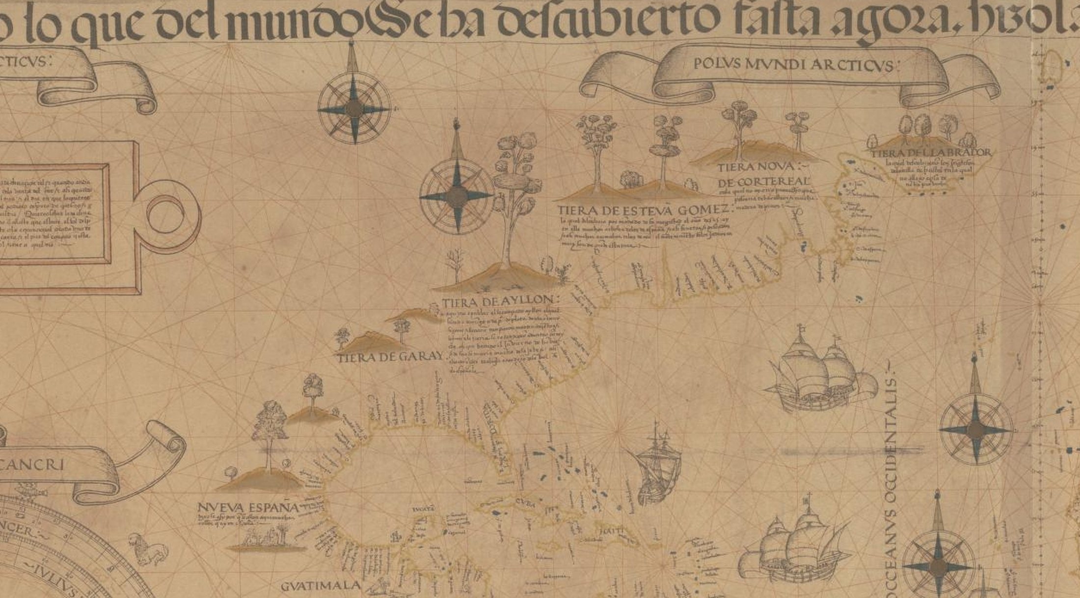
What that voyage produced, besides the wreckage of fifty-eight lives, was a map. Diogo Ribeiro's world map of 1529 shows the Atlantic coast of North America running unbroken from Florida to Nova Scotia for the first time, and it labels this stretch of it Tierra de Esteban Gómez.[8] That is how this coast entered the European mind: as the Land of Esteban Gómez, named for the man who took the captives.
And then, on paper, almost nothing for 84 years.
That silence deserves honesty rather than filler. It does not mean nothing happened. European fishing and trading vessels worked the northeast coast throughout the sixteenth century and left thin, scattered records; the men aboard them were not keeping journals for posterity. Whether any of them called here, what the Navesink learned about Europeans in those decades and from whom, and how much of that knowledge was in the room when the Halve Maen came through the Narrows — none of that is answerable from what survives. The written archive simply goes dark.
It matters, though, that the darkness is on our side of the ledger. The Navesink did not stop learning things in 1525 because Europeans stopped writing them down.