Chapter 5

Wrecks and Rescue

1839–1915 · The graveyard coast, and the service built on it

A congressman told Congress that 158 ships had been lost. Congress believed him.

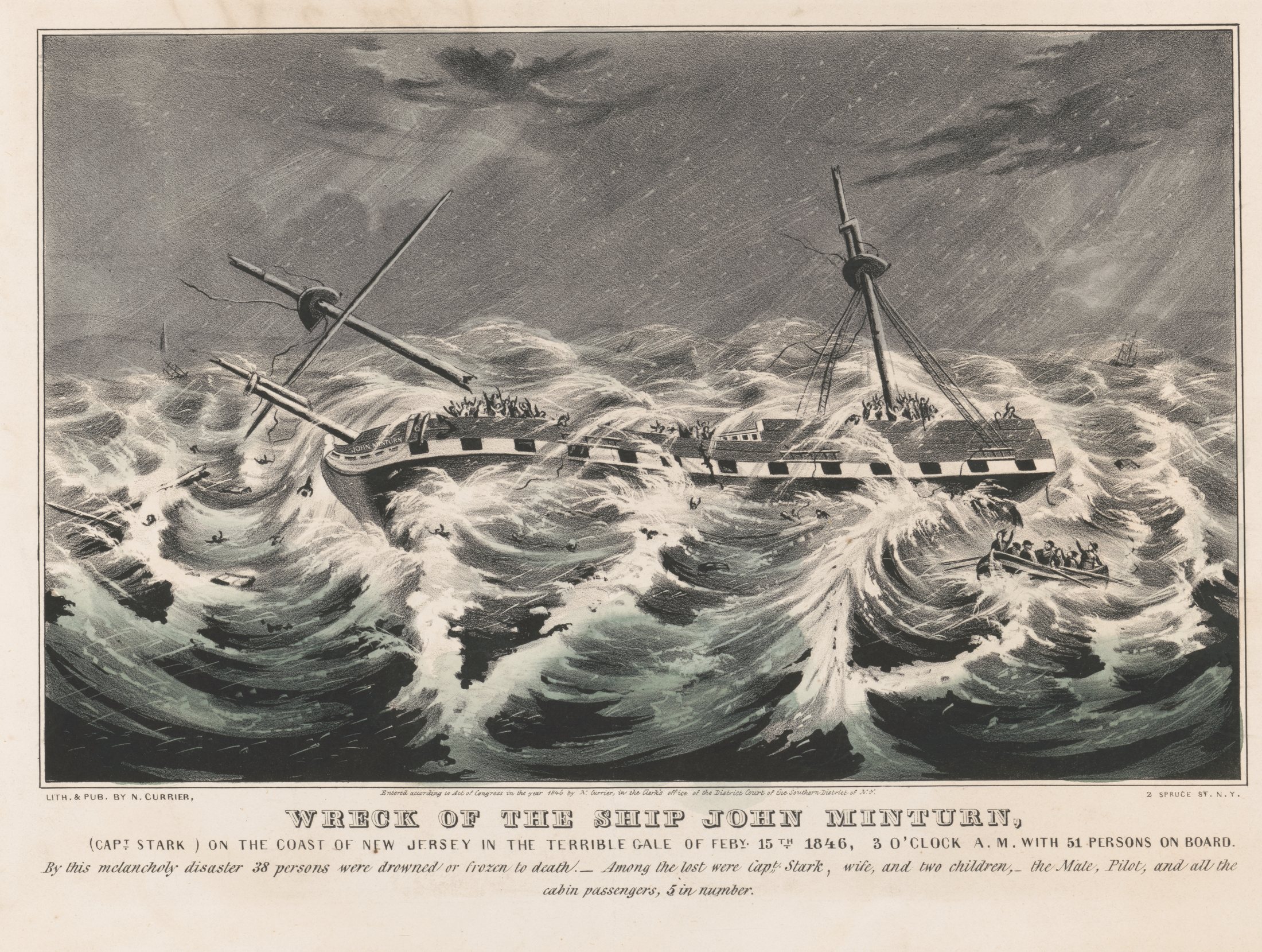
A black-and-white lithograph of a wrecked three-masted ship in a heavy following sea. The hull has broken open amidships, spars hang at angles, and figures are crowded on the remaining deck with arms raised. A small boat pulls clear at the right and people are in the water. Letterpress beneath the image reads WRECK OF THE SHIP JOHN MINTURN, with a line recording fifty-one persons on board and thirty-eight lost.

N. Currier, New York, 1846 · Library of Congress Prints and Photographs Division, LC-DIG-pga-10180. No known restrictions on publication.

Prologue

In 1848 a first-term congressman from Monmouth County stood up and told the House that 158 sailing vessels had been lost off the New Jersey coast in the previous nine years. One every three weeks, for a decade.[1]

Nobody has independently checked that number since. It was supplied to Congress by the man asking Congress for money, and it is the figure that built the American maritime rescue service.

It was also, by every other measure, believable. The approach to New York was a killing ground. From Sandy Hook to Cape May there is little natural shelter deep enough to hold a full-rigged vessel, and the ships coming in were crowded with people from Liverpool, Le Havre, and the Rhine. Most of the wrecks were night wrecks. Most were driven by winter northeasters that pushed ships off the lanes and onto sand.

The bodies washed up on the beach. In the years before the federal government built anything, the towns on this coast handled the dead the way rural towns handle any disaster — locally, awkwardly, without money.

This chapter is about how that changed. It is the shore's great working-class heroism story, and for about seventy years it was the entire relationship between the federal government and the people who lived here.

The Minturn

On the night of February 14, 1846, a northeaster came up the coast with snow behind it. By morning eight or nine ships were on New Jersey beaches. The storm took upwards of sixty lives, and it has been called the Minturn Storm ever since, after the worst of them.[2][3]

The John Minturn was a three-masted packet out of New Orleans for New York under Captain Dudley Stark, with fifty-one people aboard.[4] She made it as far as Sandy Hook, near the entrance to the harbor, with safe mooring in sight. Then the storm blew her back south and out to sea.

Stark tried to run her aground to save the people on board and struck a sandbar instead, three hundred yards off the beach at Mantoloking, in what is now Ocean County.[5]

Rescue efforts ran for eighteen hours. Several people were taken off. Many of the same men had spent the earlier part of that day at the Alabama, beached near Manasquan Inlet, where the attempt failed and the crew was lost.[2]

By the time it was over, thirty-eight of the fifty-one were dead — drowned or frozen — and among the lost were Captain Stark, his wife, and their two children, the mate, the pilot, and all five cabin passengers. Thirteen came off alive.[4][5]

What made the wreck a national story was what happened afterward. The newspapers reported widespread plundering of the dead — shore men stripping valuables from bodies and wreckage before any authority arrived — and whether they had also declined to help while the ship was visible from the beach.[3]

The New Jersey Senate appointed a commission. It reported back on March 20, 1846, and found the claims unwarranted.[3]

The finding did not matter. The picture the papers had already run — of wreckers going through the pockets of drowned immigrants — was the picture Congress voted on two years later.

Sources · Monmouth Timeline and NJ Scuba for Mantoloking, the Alabama, the eighteen hours and the thirty-eight dead · the Library of Congress catalogue record for the Currier & Ives title, which gives fifty-one aboard · the New Jersey Senate commission and its report of March 20, 1846. The letterpress under the Currier print supplies the count of those aboard and those lost, including the captain's family.

The story that pushed Congress to act — the commission found the plundering claims unwarranted, and it made no difference. Currier had the sheet registered for copyright twelve days after the storm; the color is ours.

COLORIZED

Colorized by Above the Hook · after N. Currier, New York, 1846 · source plate Library of Congress LC-DIG-pga-10180

On the record · the riderNewell had been trying for years

William A. Newell had been trying for years before the Minturn gave him his opening.

He was a physician from Monmouth County, later governor of New Jersey and then of Washington Territory. As a young man, visiting an uncle in Manahawkin, he had watched a ship break up off Long Beach Island and had never got over it. In Congress he argued that something had to be done about the Jersey coast, and got nowhere. Among the men who were not convinced were Daniel Webster and John Quincy Adams.[6]

The Minturn changed that.

On August 14, 1848, Congress appropriated ten thousand dollars for the erection of eight life-saving houses on the coast of New Jersey, between Sandy Hook and Little Egg Harbor, for the more effectual security of life and property from shipwreck.

Two things about that sentence are worth holding onto.

The first is that it was an amendment to a lighthouses bill. The entire American maritime rescue service began as a rider.[6]

The second is that it was not quite the first federal money for shore-based rescue — a law of March 3, 1847 had already made an appropriation of that kind. What 1848 did was build a system, on this coast, and every station in the country afterward descends from it.[7]

Ten thousand dollars was not much. It bought plain wooden buildings with a lifeboat, oars, some rescue gear, no permanent crew, and a volunteer keeper who lived nearby. The stations were completed in 1849, spaced ten miles apart, running from Spermaceti Cove on Sandy Hook south to Long Beach Island.[1]

It was better than nothing. It was not enough.

The wreck coast

The map above traces the wreck coast — the New Jersey approach as mariners on eastbound sailing vessels approached New York in the years before radar. The graveyard polygon covers the seventy-mile stretch where most of the 1839 to 1848 losses occurred — "most" on the strength of Newell's 158, which is the only figure there is for those years, and his own. Individual wreck sites of the two most notorious — the Minturn on the bar off Mantoloking and the New Era off Deal — are marked with the middle waypoints. The rescue infrastructure that grew up in response ran along the shore itself, plotted here as a LineString of station locations. Spermaceti Cove and Sandy Hook are the north end of the line and — by the eighteen seventies — the administrative center of the whole USLSS district.

Signature · Spermaceti CoveThree stations, and two of them still exist

Three stations have stood at Spermaceti Cove, and two of them still exist.

The first was finished in 1849 — one of the eight Newell's appropriation paid for. A rectangular wood-framed building with a gable roof, holding a surfboat, a life-car, a boat-wagon, and the gear to work them.[8]

In April 1871 Congress put $200,000 behind the idea, with paid surfmen and more stations, and the Treasury gave the job to Sumner Kimball. He sent Captain John Faunce to look at what already existed. Faunce reported back that the buildings were in poor repair, the crews unfit for service, and the stations too far apart. On his recommendation a new station went up at Spermaceti Cove in 1872 — a red house-type building — and the 1849 station was moved a hundred and sixty yards southeast and kept in use.[8]

The building standing today is the third, put up in 1894. It is a Duluth-type station, built to George R. Tolman's 1893 design and one of at least twenty-eight of that type raised for the Service — shingled walls and roof, Shingle Style massing. Its porch was enclosed and the main entrance moved in 1962.[8]

For thirty-five years all three stood together. Then in 1929 the Coast Guard rehabilitated the 1849 building and marked it The Original Life Saving Station, Erected By The Government 1848, and demolished the 1872 one.[8]

And the first one is still here. Around 1954 the Twin Lights Historical Society had the 1849 station moved up to the Twin Lights site in Highlands, where it stands as the only known survivor of the early federal life-saving stations.[8] The oldest thing Newell's ten thousand dollars bought is sitting on the hill in Chapter 6.

The 1894 station entered the New Jersey Register on March 15, 1976 and the National Register on November 30, 1981, reference 81000080. It has been inside the Sandy Hook Unit of Gateway National Recreation Area since 1974.[9]

Sources · National Park Service, Historic Structure Report: Spermaceti Cove Life-Saving Station, for the 1849, 1872 and 1894 sequence, the Faunce survey, the Duluth type and Tolman's design, the 1929 rehabilitation and demolition, and the move to Twin Lights around 1954 · the National Register listing for reference 81000080. Note: the 1929 plaque reads 1848, the year of the appropriation; the report dates the completed building to 1849.

November 13, 1854The New Era

She was worse than the Minturn, and the arithmetic of how much worse is still argued.

The New Era left Bremen in September 1854 for New York, carrying German immigrants in steerage and a small number in cabins — something around 385 people, plus crew. On November 13 she made a botched approach in a heavy northeaster and grounded on a bar off Deal Beach, about fifteen miles south of Sandy Hook.[10]

She did not break up at once. She was two hundred and fifty yards from the sand. The passengers, most of them with no English, could see the beach. Crewmen told them boats would be along soon.

How many died is not settled

240The figure most commonly repeated.
248One published immigrant-passage account.
~300The memorial at Allenhurst, dedicated 2002 — "nearly 300 German immigrants".

We do not know. We are not going to average them. The passenger count varies by source as well.

Some of the immigrants panicked and went into the surf. Most of those drowned. The vessel broke up on the fifteenth.

Boats did come.

Surfmen from three stations gathered on the beach. Sea Bright's men had tried to reach her earlier, while she was still driving south down the coast. None of the three could launch into that sea. A lifeline was eventually made fast to the wreck and some of the crew were brought in on it.[11][12]

Abner Allen, the earliest settler of what is now Allenhurst and keeper of the local lifeboat house, was the first rescuer to reach the scene. His town put up an anchor with his name on it a hundred and forty-eight years later.[13]

Men turned out, in numbers, and stood on a beach two hundred and fifty yards from close to four hundred people, counting crew, and could not reach them. That is the argument for a professional service, and it is a better argument than absence would have been.

The grave. The immigrant dead were pulled from the surf over several days and buried in a mass grave in a potter's field near the Sandy Hook Light. The exact location has been disputed for a hundred and seventy years. The NPS file treats it as folklore-adjacent — probably real, probably near the ground now marked with an interpretive sign, not verified to a survey. We hold it in the same posture, and it is listed that way in the verification register.

Sources · Monmouth Timeline for the November 13, 1854 grounding · Monmouth Beach Life for Sea Bright Station No. 3 having the first attempt · Duke Migration Memorials for the Allenhurst anchor, Abner Allen, and the "nearly 300" inscription. Open: the death toll and the passenger count both vary by source, and both are shown rather than resolved. The sources also word the place three ways for the same few miles of shore — off Deal Beach, off Deal Lake, off Asbury Park. Chasing: an account exists of cut-open leather money belts found empty under a tree after the wreck. If it can be confirmed in a newspaper or a county history it closes this chapter's circle. It is not published on the strength of the source it currently sits in.
The machine on the coastForty-one stations, numbered north to south

By the 1870s the stations had multiplied along the East Coast and the Great Lakes, and each state's shoreline became a numbered district.

New Jersey was District No. 4. The stations ran north to south: Sandy Hook was Station No. 1. Spermaceti Cove was No. 2. Sea Bright was No. 3. Cape May was No. 40. New Jersey ended up with more life-saving stations than any other state — forty-one of them, which is one more than the highest number on the list. The two sources are not reconciled here: NPS gives Cape May as No. 40, and the count of forty-one rests on a single local history.[1][12]

District No. 4

Forty-one stations, numbered north to south

By the 1870s each state's coastline was a numbered district and each station a number in it. New Jersey ran north to south, and ended up with more life-saving stations than any other state.

  1. No. 1Sandy Hook
  2. No. 2Spermaceti Cove
  3. No. 3Sea Bright
  4. 4
  5. 5
  6. 6
  7. 7
  8. 8
  9. 9
  10. 10
  11. 11
  12. 12
  13. 13
  14. 14
  15. 15
  16. 16
  17. 17
  18. 18
  19. 19
  20. 20
  21. 21
  22. 22
  23. 23
  24. 24
  25. 25
  26. 26
  27. 27
  28. 28
  29. 29
  30. 30
  31. 31
  32. 32
  33. 33
  34. 34
  35. 35
  36. 36
  37. 37
  38. 38
  39. 39
  40. No. 40Cape May

Numbered north to south. Forty-one stations in New Jersey, more than any other state.

In 1878 Congress folded the whole thing into a paid federal agency inside the Treasury and named it the United States Life-Saving Service. The legislation was signed on June 18 by President Rutherford B. Hayes.[8]

Sumner Increase Kimball ran it from that day until the day it ceased to exist, thirty-seven years later. He had been appointed in 1871 to implement the new system Congress had just funded, and had spent the decade turning a network of unmanned sheds into a service: he reorganized the Revenue Marine Bureau into districts, numbered the stations, and acted on Captain John Faunce's survey, which found the buildings in poor repair, the crews unfit, and the stations too far apart.[8][14]

In 1871 the twenty-eight old stations on the Jersey Shore came down and larger ones went up in their place. They were painted red so a man on a sinking ship could see them from the water. People called them the Red House stations.[1]

The model was the same everywhere. Small stations, closer together than the ten-mile spacing of 1849. Six-man crews, rated by experience, a keeper in charge. Weekly drill with the boats and the beach apparatus. Tower watch by day. Beach patrol on foot every night.[1]

The men who did it were local — fishermen and baymen who already knew the water — and they had a sentence they said to each other about the job.

You have to go out, but nothing says you have to come back.

Coda · the surfmenThe surfmen

In 1915 the Life-Saving Service merged with the Revenue Cutter Service to form the United States Coast Guard.

Its records are one of the great primary-source collections in nineteenth-century American labor history: annual reports, station logs, wreck reports, rosters, in the handwriting of men who were paid very little to walk a beach in the dark.

The surfmen are worth remembering by name where the names can be recovered. NPS Gateway holds partial rosters for both Sandy Hook and Spermaceti Cove going back to the 1870s, and the Local Legends feature on this site will spotlight one every quarter.

Sources

  1. The Lifesavers of Sandy Hook. National Park Service · Gateway National Recreation Area. Source for the provenance of the 158 figure — that in 1848 Monmouth County Congressman William A. Newell reported to Congress that 158 sailing vessels had been lost off the New Jersey coast between 1839 and 1848. It is the advocate's number, given inside the appropriation request; no independent corroboration has been found. Also the source for the stations being completed in 1849 ten miles apart from Spermaceti Cove south to Long Beach Island, for the 1871 reorganization in which the twenty-eight old Jersey Shore stations were replaced by larger ones painted red — the Red House stations — and for New Jersey becoming District No. 4 with stations numbered north to south, Cape May being No. 40. Also the source for weekly drill and for daily tower watches with nightly beach patrols.
  2. Wreck of the John Minturn. NJ Scuba. Concurs on Mantoloking, and identifies the Alabama as the ship beached near Manasquan Inlet hours earlier the same day, with many of the same men attempting both rescues. Source for the eighteen hours of rescue effort and for nine ships wrecked on New Jersey beaches in the storm.
  3. The Minturn Storm and the New Jersey Senate commission. Source for the newspaper reports of widespread plundering of the dead, for the New Jersey Senate appointing a commission to investigate the claims, for the commission reporting on March 20, 1846 that the claims were unwarranted, and for the storm claiming upwards of 60 lives, of which the Minturn was the largest single loss.
  4. Wreck of the ship John Minturn (Capt. Stark) on the coast of New Jersey in the terrible gale of Feby. 15th 1846, 3 o'clock a.m., with 51 persons on board . The lithograph's own title supplies the count of 51 persons aboard and names Captain Stark. Library of Congress: no known restrictions on publication; the Library does not own rights, does not license, and charges no permission fees.
  5. The wreck of the John Minturn. Monmouth Timeline. Source for Captain Stark attempting to run the ship aground and striking a sandbar off Mantoloking, in what is today Ocean County, and for 38 of those aboard perishing, with other wrecks in the same storm accounting for 22 more lives.
  6. William A. Newell and the first life-saving stations. Island Beach State Park history. Source for Newell having watched a ship break up off Long Beach Island while visiting an uncle in Manahawkin, for his arguing the case in Congress without success, for Daniel Webster and John Quincy Adams being among those initially unconvinced, and for the $10,000 being successfully attached to a lighthouses bill.
  7. Dennis R. Means. A Heavy Sea Running · the formation of the U.S. Life-Saving Service. National Archives. Source for the law of March 3, 1847 carrying the first federal appropriation for rendering assistance from the shore to victims of shipwreck — which is why the 1848 Newell Act is described here as the first to build a system rather than the first federal money.
  8. Historic Structure Report: Spermaceti Cove Life-Saving Station. National Park Service · Gateway National Recreation Area. Link The authority for the rebuild sequence this chapter had previously asserted without a citation. Source for the 1849 station as a rectangular gable-roofed wood-framed building holding a surfboat, life-car and boat-wagon; for Congress approving $200,000 in April 1871 for paid surfmen and additional stations, the Treasury appointing Sumner Increase Kimball to implement it, and Captain John Faunce's survey finding the stations in poor repair, the crews unfit and the stations too far apart; for the 1872 red-house-type station and the 1849 building being moved 160 yards southeast; for Kimball reorganizing the Revenue Marine Bureau into districts and numbering the stations, with New Jersey as the Fourth District; for the legislation of June 18, 1878 signed by President Hayes and Kimball's confirmation as General Superintendent; for the surviving 1894 building as a Duluth-type station after George R. Tolman's 1893 design, one of at least twenty-eight; for the 1962 porch enclosure; for the 1929 rehabilitation of the 1849 station as "The Original Life Saving Station, Erected By The Government 1848" and the demolition of the 1872 station in the same year; and for the Twin Lights Historical Society moving the 1849 station to the Twin Lights site around 1954, where it survives as the only known example of the early federal life-saving stations.
  9. Fort Hancock U.S. Life Saving Station (Spermaceti Cove No. 2). National Register of Historic Places · reference 81000080. Listed on the National Register November 30, 1981; New Jersey Register March 15, 1976. Inside the Sandy Hook Unit of Gateway National Recreation Area since 1974.
  10. The wreck of the New Era. Monmouth Timeline. Source for the November 13, 1854 grounding on a bar off Deal Beach, about fifteen miles south of Sandy Hook, and for the vessel breaking up on the fifteenth.
  11. The New Era · a published immigrant-passage account. unverified Gives 374 German immigrants in steerage and eleven more in cabins, and 248 lives lost — one of the three death tolls shown in the chapter. Also the source for personnel from three life-saving stations gathering but being unable to launch, and for a lifeline eventually being made fast and some of the crew rescued by it. OPEN: this account also carries a story of cut-open leather money belts found empty under a tree after the wreck. It is not published until it can be confirmed in a newspaper or a county history.
  12. Sea Bright Life-Saving Station No. 3. Monmouth Beach Life. Source for Sea Bright as Station No. 3 and for its surfmen having the first attempt at the New Era, for New Jersey ending up with forty-one life-saving stations — more than any other state — and for the surfmen's code: you have to go out, but nothing says you have to come back.
  13. The New Era memorial, Allenhurst. Duke University · Migration Memorials. Source for Abner Allen — the earliest settler of what is now Allenhurst and keeper of the local lifeboat house — being the first rescuer to reach the scene, and for the memorial anchor dedicated in 2002, whose inscription reads "nearly 300 German immigrants".
  14. Sumner Increase Kimball. U.S. Coast Guard historian's office. General Superintendent of the United States Life-Saving Service for its entire existence, 1878 to 1915.