Chapter 3

Purchase and Settlement

1651–1764 · The century between the deed and the lantern

What the deeds said was sold, and what was in practice kept.

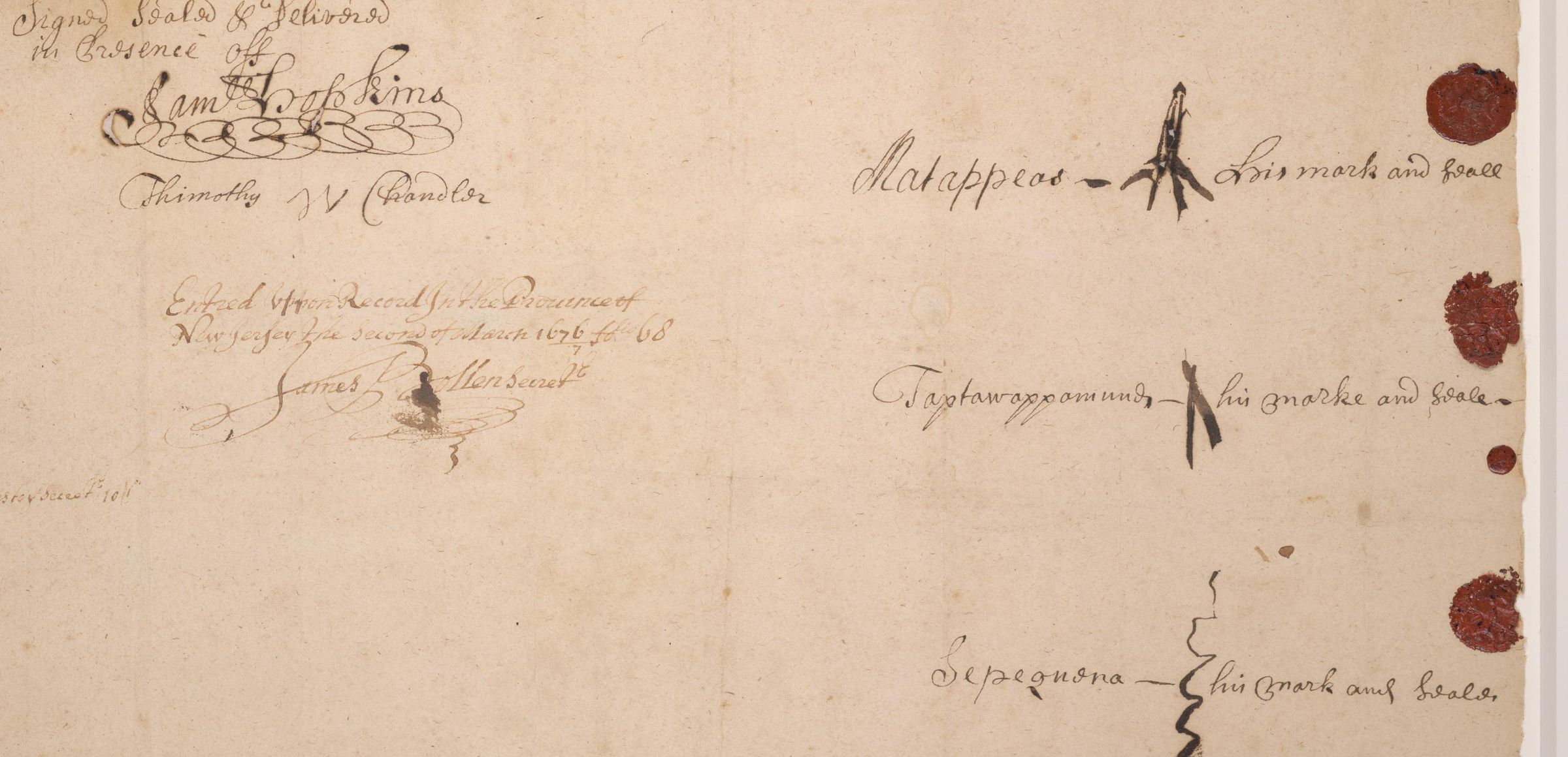
A detail of the foot of a 1674 manuscript deed in brown iron-gall ink on laid paper. At right, three names in a clerk's hand — Matappeas, Taptawappamund, Sepequena — each followed by a hand-drawn mark and the words "his mark and seale", with a disc of red wax beside each. At left, the witness signatures and a note recording the deed's entry in the Province of New Jersey on the second of March 1676/7.

Deed from Matappeas, Tawapung, and Seapoekne to John Bowne, Richard Hartshorne, and James Grover for land in Toponemus · 24 August 1674 · detail. Princeton University Library, Manuscripts Division · General Manuscripts Miscellaneous Collection, gift of Harry Irvin Caesar, Class of 1913 · No Known Copyright (rightsstatements.org/vocab/NKC/1.0/).

PrologueForever

Forever. That is the word the settler record uses for what thirteen shillings bought at the tip of Sandy Hook in August of 1678.[1] A deed. A price. A single Anglo-Saxon word that closes any door.

Read further down the same document and a second clause sits waiting — one about beach plums, and hunting, and fishing, and dry trees fit for canoes. Rights the Navesink had held along this shore for longer than England had existed as a country.

What that clause does is the question this chapter cannot answer.

Not because the seventeenth century was vague. Because we have never seen the page. Everything anyone knows about the most consequential document in the history of this ground comes through a mid-twentieth-century popular historian's retyping of papers that are not reproduced anywhere online — and in his version, every word that decides who granted what to whom is inside a parenthesis he added himself.

That is not a footnote to this chapter. That is the chapter.

The instrumentEvery word that decides it is in a parenthesis

Here is the transcription as Fletcher Pratt printed it, with his editorial glosses shown. Move the switch and they disappear.

Watch what happens to the meaning.

Monmouth Deeds · August 8, 1678 Original not sighted
Show

Whereas the Indians pretend that formerly, when they sold all the land upon Sandy Hook they did not sell, or did except liberty retained the right to get plumbs beach plums when they please, and to hunt upon the land and fish, and to take dry trees that suited them for cannows canoes

I, Richard Hartshorne, … for peace and quietness sake, and to the end that there be no cause for trouble with the Indians and that I may not for the future have trouble with them as formerly I had, in their dogs killing my sheep … I have agreed to their plumbing on Sandy Hook, hunting, fishing, fowling, getting cannows, etc. they in turn to convey to me forever… Sandy Hook and lands adjoining to it, the Highlands of Navesink in consideration the said Richard Hartshorne hath paid unto the said Jawavapon, thirteen shillings…

As Fletcher Pratt printed itHartshorne concedes the liberties; the Navesink convey the land forever. Seven bracketed insertions carry that reading.

With Pratt's insertions removedThe same words now read as Hartshorne acquiring the liberties. Nothing in the document decides between the two.

Words in the transcription Added by Fletcher Pratt, c. 1955 — not in the documentHover a marked word for its attribution

With the brackets, Hartshorne concedes the liberties and the Navesink convey the land forever. Without them, the same words read as Hartshorne acquiring the liberties — the plums, the hunting, the fishing, the canoe timber — for thirteen shillings.[1]

There is a second transcription in circulation, tertiary and unverified, and it points the second way: Hartshorne granted all the liberty of pluming on Sandy Hook, hunting fishing and fowling, getting cannowes.[2]

So there are two possible chapters here.

In one, thirteen shillings bought land the Navesink kept the use of, and the deed is a record of a bargain that failed to settle anything. In the other, thirteen shillings bought the use itself — the last thing they still held after the land had already gone — and the deed is a record of a bargain that settled it permanently.

We don't know which. We are not going to pretend.

If the brackets are right

Thirteen shillings bought a peninsula whose use the Navesink kept. The deed records a bargain that settled nothing.

If they aren't

Thirteen shillings bought the use itself — plums, hunting, fishing, canoe timber. The land had gone in 1664 and 1677. This closed the last of it.

Two possible chapters. We don't know which. We are not going to pretend. A note on one word: in seventeenth-century legal English, pretend means to claim or assert, not to make believe. The clause recites a claim in the ordinary voice of a deed.

1674 · Tinton FallsWhat one of these looks like when it survives

We can't show you the Sandy Hook deed. We can show you its neighbor.

In 1674, three of the twelve Monmouth patentees — John Bowne, Richard Hartshorne, and James Grover of Middletown — took a deed for the land the English called The Falls and the Lenape called Warumnonung. It is now Tinton Falls. The consideration was sundry species of trading goods.[3]

  • Matappeas — his mark
  • Taptawappamund — his mark
  • Sepequena — his mark

The document survives. It is at Princeton. It carries the marks and seals of Matappeas, Taptawappamund, and Sepequena, sachems of the Toponemese — the inland inhabitants — of the Lenape.[3]

Their marks are on it. Not a name a clerk wrote down and a later historian retyped. Marks, made by three men, on a sheet you can look at.

That is what this chapter is missing about Sandy Hook, and now you know exactly what shape the hole is.

1651–1664Before the paper

Fourteen years before the Patent, in November of 1651, a Dutch investor named Cornelius Van Werckhoven bought a tract called Nevesings.[4] He never took possession. The paper survives; the settlement does not.

Thirteen years after that, in the spring of 1664, the record has Popamora — or Passachquon, depending which nineteenth-century county historian is telling it — selling the neck of land from Sandy Hook west to Keansburg and south to the Navesink River.[5] Chapter 2 carried that deed and its unresolved naming. This chapter does not pick a version either.

Ten years of Dutch, English, and Lenape hands running across the same ground. None of it opened anything. It was already open.

April 8, 1665The appearance of propriety

On April 8, 1665, deputy governor Richard Nicolls granted twelve men a triangle. Sandy Hook west to the mouth of the Raritan, up the river about twenty-five miles, southeast to Barnegat Bay.[6] The Monmouth Patent. The paper origin of every later chapter on this site.

Say the twelve names out loud, in the order the record lists them. William Goulding. Samuel Spicer. Richard Gibbons. Richard Stout. James Grover. John Bowne. John Tilton. Nathaniel Sylvester. William Reape. Walter Clark. Nichols Davis. Obadiah Holmes. Mostly Long Island Quakers and Baptists, mostly out of Gravesend, crossing to a shore they had already been walking and trading on for years.[6]

It was recorded in New York on November 8, 1665.[6] The reason it needed recording is the reason this chapter exists: the Patent's own language required that dealings with, in its words, the land's indigenous inhabitants carry the appearance of propriety.[6]

Appearance. In the founding document. In 1665.

Chapter 2 named what that phrase concedes from the Navesink side. This chapter watches the appearance get produced — in signatures on paper that argue with themselves while the ink is still wet.

1641–1722A man asks for a window

Richard Hartshorne was baptized at St. Peter's Parish in Leicestershire on the twenty-fourth of October, 1641, four miles from Loughborough, about as far from a coastline as England allows.[2]

He was in America by 1669 and married Margaret Carr in Rhode Island on the twenty-seventh of April, 1670. Her father gave them a partly fenced piece of ground, and Hartshorne asked a man named John Hawes to finish the house on it — a chimney, a cellar, and a window. They moved in a month after the wedding. He probably hosted George Fox there; Fox wrote about the visit in his journal. Their son Robert Hartshorne was born in December of 1671.[2]

Four years later he was gone. In 1674 he walked onto the Bayshore side of the Navesink Highlands and called it Portland Poynt. He was thirty-three.

He would spend the next forty-eight years acquiring this ground and die on it, on the twenty-second of May, 1722, aged eighty-one, holding close to 2,400 acres — most of Sandy Hook, most of the Highlands.[2] His grandson William Hartshorne put up a cabin around 1720 on two hundred acres above the Navesink. It stands restored today inside Hartshorne Woods Park, and you can walk to the door on a Saturday between May and November.[7]

The chimney, the cellar, and the window are the last ordinary things in his story.

1677A spice and a coin

In 1677 he took a tract of 2,320 acres from the Navesink Lenape, with the East Jersey proprietors standing as overseers.[1] The lease terms, as Pratt reports them, read now like a weather report for the whole century: the whole range and benefit of herbage and feed for hogs and cattle, with privilege of fowling and fishing, upon the beach called Sandy Hook, for twenty-one years — rent, one peppercorn, yearly, if demanded.[1]

A peppercorn. It is a legal fiction, a token consideration to make a conveyance binding without anything of value changing hands, and it is the most honest thing in the file. Between the peppercorn in 1677 and the thirteen shillings in 1678, the paper record of how a peninsula changed hands amounts to a spice and a coin.

And then the ground stayed in dispute anyway.

Pratt preserves what Hartshorne is said to have recorded of the standoff that followed. The Navesink came to his house. They told him the house was theirs. They said they would kill his cattle and burn his hay if he did not either buy the land outright or leave.[1]

We report that as tradition, because that is what it is — a mid-century secondary source quoting a document this project has not sighted. But note what even the settler's own account concedes, if it is his: that a year after a signed conveyance, the people who signed it did not consider the matter closed.

The deed ended the dispute by writing the dispute into itself.

August 8, 1678Thirteen shillings

On the eighth of August, 1678, Hartshorne paid thirteen shillings to a sachem the deed names as Jawavapon.[1]

Or Vowavapon. The Borough of Highlands' own history gives one spelling; the borough's own timeline gives another, and adds a second sachem, Tucus, whom the deed transcription never mentions. One name, two renderings, on the same website, and a party to the transaction who appears and disappears depending which page you read.

That is the state of the record on the man who sold Sandy Hook.

What thirteen shillings bought depends entirely on a set of parentheses. If Pratt's brackets reflect the original, it bought a peninsula whose use the Navesink kept. If they don't, it bought the use — and the peninsula had already gone in 1664 and 1677, and this was the transaction that closed the last of it.

Either way, one thing in the document is not in dispute, because it appears in every version: the word forever.

Thirteen shillings, and forever. Thirteen shillings, and whereas the Indians pretend that formerly they did not sellpretend here in its seventeenth-century legal sense, to claim or to assert, not to make believe. We can't tell you which way the grant runs. We can tell you that both phrases were written on the same day, by the same hand, about the same sand.

1678–1762Eighty-four years

That is the shape of what followed. Not a story, a duration.

Quaker meetings established by 1670. As many as eighty families arriving in the first years after the Patent, out of Long Island, Rhode Island, and Massachusetts.[8] Monmouth County formed on the seventh of March, 1683. On the thirty-first of October, 1693, the county divided into Freehold, Middletown, and Shrewsbury, and Middletown was organized — a township drawn on ground Hartshorne had walked in on nineteen years earlier.[8]

The peninsula itself was never really settled. It was worked. Grazed, fowled, timbered while the timber held. An outlier of the Bayshore towns, held under one family's title, unbuilt and unfortified, for four generations.

Eighty-four years went by. Eighty families' children farmed the same ground. The peninsula waited.

May 16, 1762Four acres

On the sixteenth of May, 1762, the Hartshorne family sold four acres.[1]

Not the peninsula. Not the Highlands. Not the century-old title. Four acres at the outermost tip of Sandy Hook, to a consortium of New York merchants who wanted somewhere to put a lighthouse.

Two years and twenty-six days later, the lantern was lit.

We know what that deed said, and we know it from a source you can read yourself — because forty-three years afterward, the Secretary of the Treasury had to explain the terms to the President of the United States.[9]

No tavernto be established on the premises
Two cowsand no more, kept on the four acres
No roadopened from the parcel

Albert Gallatin explained the cow clause himself: the whole peninsula was pasture, and the shifting sands meant no permanent division fence could be kept without enormous expense.[9]

The sand that Chapter 0 spends a section on — the sand that walks north, that moved the tip a mile and a half in two hundred years — turns up here as a term of property law. You cannot fence this place. So: two cows.

Coda · 1805Sordid

The Hartshornes kept the rest of Sandy Hook for another century, and by 1805 the family was in a long dispute with the federal government about beacons, roads, cattle, and whether the lighthouse keeper could go on running a tavern.[9]

On the sixteenth of November, 1805, Thomas Jefferson wrote to Gallatin about it.

mr Hartshorne's conduct has been so sordid as to prove that nothing restrains him from any robbery private or public but the power of the law.
Thomas Jefferson to Albert Gallatin · November 16, 1805 · Founders Online, public domain

Read in its own frame. Jefferson is describing an argument over beacons with a later Richard Hartshorne, eighty-three years after the first one died. It is not a judgment on 1678, and we do not offer it as one.

But it is the last word in the file, and the file is about a family that acquired a peninsula through documents that argue with themselves. A hundred and twenty-seven years after the peppercorn, a sitting President described the holder of that title as restrained from robbery only by law.[10]

Then the heirs sold most of the Hook to the federal government in 1806, and the peninsula became the public ground it has been ever since.

That is a later chapter's opening. This one ends where it began — on four acres, at the tip of the spit, on a piece of paper.

Two years later, the lantern was lit.

On sources for the Lenape material

The Navesink Highlands and Sandy Hook are the ancestral homeland of the Navesink band of the Lenape. Lenape nations continue to exist today. The Sand Hill Indian Historical Society[11] in Monmouth County is the community-authored source closest to this ground. The Nanticoke Lenni-Lenape Nation of New Jersey[12] and the Ramapough Lenape Nation[13] are Lenape nations elsewhere in New Jersey whose published materials inform the wider picture. Written with, not about.

We have not written this in partnership with Lenape descendant historians, and we are not going to imply otherwise. That means the sections about Navesink life here rest on published archaeology and on documents written by Europeans, with all the limits that carries.

If you know this material — through study, through family, through the Lenape communities whose history this is — and we have gotten something wrong, or flattened something that deserved better, we want to hear it. Corrections are credited and the chapter gets revised.

These are the people to consult for the fuller story of what this ground has meant, and continues to mean, to Lenape families. Read this as a beginning, not the last word.

Sources

  1. The Story of Highlands, New Jersey. Borough of Highlands, New Jersey. Link A borough-hosted transcription of Fletcher Pratt's mid-20th- century Highlands history. Cited for the 1677 2,320-acre tract, the pepper-corn lease language, the thirteen-shillings payment of August 8, 1678 to a sachem the deed names as Jawavapon, and the "Whereas the Indians pretend that formerly they did not sell" clause. Pratt himself is a secondary source whose primary citations to Hartshorne's papers and the Monmouth County deed books are not reproduced online. Every deed quote in Ch. 3 travels through this transcription.
  2. Richard Hartshorne (settler). Wikipedia. Link unverified Tertiary source. Cited for Hartshorne's 1641 birth in Hathern, Leicestershire, his emigration to Rhode Island circa 1669, his 1670 marriage to Margaret Carr, his 1674 arrival at Portland Poynt, his roughly 2,400-acre total holdings by the late 1670s, his May 22, 1722 death, and the deed clause "all the liberty of pluming on Sandy Hook, hunting fishing and fowling, getting cannowes upon Sandy Hook or any part of the lands of the new sands." That last clause reads compatibly with the highlandsnj-story "whereas the Indians pretend" clause and is likely the same document phrased differently.
  3. New Jersey land deed, 1674. Princeton University Library, Manuscripts Division. 1674. An original 1674 deed granting the land the Lenape called Warumnonung and the English called The Falls — now Tinton Falls — to John Bowne, Richard Hartshorne, and James Grover of Middletown, in return for "sundry species of Tradeing goods". It bears the marks and seals of Matappeas, Taptawappamund, and Sepequena, sachems of the Toponemese. General Manuscripts Miscellaneous Collection, gift of Harry Irvin Caesar, Class of 1913. Dated 24 August 1674 and entered upon record in the Province of New Jersey on 2 March 1676/7. Princeton publishes the item under No Known Copyright. Cited here as the surviving neighbor of the unsighted Sandy Hook deed.
  4. Navesink tribe. Wikipedia. Link unverified Tertiary source. Cited for the November 1651 Cornelius Van Werckhoven purchase of a tract called "Nevesings", and for Passachquon as the sitting sachem at the 1664 Dutch surrender. Both attributions travel via Ruttenber's History of the Indian Tribes of Hudson's River, which has not been sighted directly this session.
  5. Lenape Chief Sells Navesink Highlands. Monmouth Timeline. Link Cited for continuity with Ch. 2. Dates the Popamora sale to March 25, 1664 and records the twenty-year continuation of Navesink use of the land after that first deed. The Popamora / Passachquon naming conflict is held open, on the Ch. 2 stance.
  6. The Monmouth Patent. Monmouth Timeline. Link Source for the April 8, 1665 grant date, the list of twelve patentees, the triangular tract from Sandy Hook to the mouth of the Raritan to Barnegat Bay, the November 8, 1665 New York recording, and the "appearance of propriety" language. Same source cited in Ch. 2; Ch. 3 quotes different clauses.
  7. Historic Portland Place. Monmouth County Park System. Link Source for the 200 Hartshorne Road (Locust) address of Historic Portland Place, its location inside Hartshorne Woods Park, its c.1720 cabin origin, and its 2008 bequest to the county park system. The park page describes the house; it does not itself source the Hartshorne deeds.
  8. Middletown Township, New Jersey. Wikipedia. Link Cited for the October 31, 1693 organization of Middletown Township as one of Monmouth County's three original townships (Freehold, Middletown, Shrewsbury), and for the arrival of early families from Long Island, Rhode Island, and Massachusetts under the Patent in the first years after 1665.
  9. Albert Gallatin to Thomas Jefferson, 15 November 1805. Founders Online, National Archives. November 15, 1805. Primary source, public domain. Gives the terms of the 1762 four-acre deed as the Treasury understood them in 1805: no tavern on the premises, no more than two cows, no road opened — with the shifting sands cited as the reason no permanent division fence could be kept. Also records that New York built the light and keeper's house and ceded both to the United States in 1790.
  10. Thomas Jefferson to Albert Gallatin, 16 November 1805. Founders Online, National Archives. November 16, 1805. Primary source, public domain. The "sordid" line. Jefferson is writing about an 1805 dispute over beacons with a later Richard Hartshorne, eighty-three years after the first one died; it is not a judgment on the 1678 deed and this chapter does not present it as one.
  11. Sand Hill Indians. Native American Genealogy, Lincroft. Link The only one of the three communities rooted in the Navesink/Monmouth County region. Cited with Ch. 0's framing.
  12. Nanticoke Lenni-Lenape Tribal Nation. Nanticoke Lenni-Lenape Tribal Nation. Link The nation's own history page. HQ in Bridgeton, Cumberland County — south Jersey, not the Navesink region itself. Cited with Ch. 0's framing.
  13. Ramapough Lenape Nation. unverified Based in Mahwah, Bergen County — not the Navesink region. No stable official URL could be confirmed as of July 2026. Cited with Ch. 0's framing.